Waterfalls, Mountains, Rivers and Lakes of Madagascar
Beyond the wildlife, Madagascar’s natural features are strung across the parks rather than standing alone. Pic Boby at 2,658 metres is the highest summit walkers can reach, the Tsiribihina is the classic river descent, and waterfalls at Amber Mountain, Ranomafana and Isalo are reached on park circuits. Most of these are things you walk to rather than destinations you visit.
Mountains and Summits
Maromokotro in the Tsaratanana massif is the highest point in Madagascar at 2,876 metres. It sits inside an integral nature reserve closed to general visitors, and reaching it is a remote expedition requiring permits rather than a trek.
Pic Boby at Andringitra, 2,658 metres, is the practical objective and the highest summit ordinary walkers can reach. Malagasy speakers call it Imarivolanitra, meaning close to the sky; the other name belongs to a dog that accompanied the first recorded ascent in 1956.
The climb from the plateau camp takes two to three hours on rock and grass with no technical sections, and the three-day Imarivolanitra circuit is the standard route. This is the coldest ground in Madagascar with frost normal on the plateau.
Mount Ambohitra at Amber Mountain reaches 1,475 metres, the highest point in the north, with the Cratère Renard circuit running about 12 km on the steeper wetter side.
Marojejy’s summit at 2,132 metres is reached on a four to five day trek through cloud forest. Pic Saint Louis behind Fort Dauphin takes several hours return and gives the clearest view of that region’s geography.
The highest mountain in Madagascar is closed to visitors. The highest one you can walk up is Pic Boby, and the route is a three-day circuit that occasional hikers manage.
Waterfalls
Madagascar’s waterfalls sit inside parks rather than standing as separate attractions, which means reaching them involves a circuit and a guide.
Amber Mountain holds the best cluster. The Grande Cascade drops about 80 metres and forms the head of the Antomboka river. The Petite Cascade sits on an easier route, and the Cascade Sacrée at Ampijoroana is treated as sacred by local communities and shallow enough at the base for a swim.
Ranomafana has the Namorona falls, with the river cutting through the park and dropping east toward the coast. Marojejy has the Humbert waterfall, a short walk from Camp Mantella.
Isalo has the Cascade des Nymphes in the Namaza gorge, falling into a deep basin where the water stays cold year-round, with the Piscine Noire and Piscine Bleue further along.
Zahamena has a substantial waterfall near the Ranomitsanga camp, close enough to hear through the night. Tsingy de Namoroka and Andringitra both hold falls on their circuits.

Rivers and River Trips
The Tsiribihina is the classic Madagascar river descent, two or three days by pirogue from Miandrivazo down to Belo sur Tsiribihina, camping on sandbanks and passing villages reachable no other way. It is flat water rather than whitewater, and the appeal is the pace and isolation.
The Manambolo cuts a gorge at Tsingy de Bemaraha where pirogue trips run beneath cliffs rising a hundred metres, past Vazimba burial sites set into ledges. Nile crocodiles live in the river, watched for by the boatmen.
The Mangoky is one of the longest rivers in Madagascar, forming the northern boundary of Mikea National Park. The Betsiboka empties into Bombetoka Bay near Mahajanga carrying so much eroded red soil that the plume is visible from the air, a stark illustration of upstream deforestation.
The Namorona at Ranomafana offers kayaking, and the Mandrare in the deep south gives its name to the valley holding Berenty and the community camps.
For summits. Pic Boby at Andringitra over three days, Marojejy’s peak over four or five, Mount Ambohitra at Amber Mountain on a day circuit, Pic Saint Louis at Fort Dauphin in a morning.
For water. The Tsiribihina descent over two or three days, the Manambolo gorge by pirogue at Bemaraha, the Pangalanes canal on the east coast, kayaking on the Namorona at Ranomafana.
For swimming. The Piscine Naturelle at Isalo, the Cascade Sacrée at Amber Mountain, Rianasoa at Mantadia, the natural pools at Tsingy de Namoroka. All reached on park circuits.
The Pangalanes Canal
The Canal des Pangalanes is a chain of natural lagoons, rivers and dug channels running parallel to the east coast for several hundred kilometres, built up during the colonial period to move goods without facing the open ocean.
Boat trips run from Toamasina for a half day, a full day or several days heading south, passing village life along the water, fishermen in pirogues and birdlife in the reed margins.
Kayaking is the quieter alternative for a half day. Longer trips south reach the Palmarium reserve, where aye-ayes are provisioned on a small island for night viewing, and eventually Manakara where the FCE railway comes down from Fianarantsoa.
The lagoons hold waterbirds and the mangrove sections support crabs, waders and juvenile fish.

Lakes and Crater Lakes
Lake Alaotra is Madagascar’s largest lake, sitting in a plain northeast of Antananarivo, and holds the bandro or Lake Alaotra bamboo lemur, which lives in marsh reeds and nowhere else on earth. Dawn canoe trips from Andreba village are community-run.
Lake Tritriva near Antsirabe is a collapsed volcanic crater holding deep green water ringed by cliffs and pines, with a local legend of two drowned lovers attached to it. Lake Andraikiba closer to town is larger and gentler.
Lac Ravelobe at Ankarafantsika holds Madagascar fish eagles and a breeding population of Nile crocodiles left undisturbed because the lake is a doany, a place of worship. Swimming is not permitted.
Tsimanampetsotsa surrounds a soda lake too saline to hold fish, fringed by greater and lesser flamingos, with blind cave fish in the limestone below.
Mont Passot on Nosy Be has eight sacred crater lakes below the summit, several carrying restrictions on how close visitors may go. Lac Anosy in Antananarivo is the heart-formed lake ringed by jacarandas that flower purple around October.
Swimming safety varies considerably. The natural pools at Isalo and Tsingy de Namoroka are safe and used routinely. Nile crocodiles occur in rivers and lakes across Madagascar, including Lac Ravelobe and the Manambolo. Bilharzia is present in fresh water in some regions. Follow guide instructions rather than guessing, and treat the sea and the marked park pools as the safe options.
Geological Features and Rock Formations
The tsingy are Madagascar’s most distinctive geology, limestone dissolved into fields of razor-edged pinnacles. Tsingy de Bemaraha holds the largest, Ankarana the most accessible, and Tsingy de Namoroka the least visited with the longest cave system in Africa beneath it.
The Red Tsingy near Diego Suarez is entirely different, soft laterite carved by the Irodo River into crimson spires, actively eroding and formed partly because deforestation exposed the soft strata.
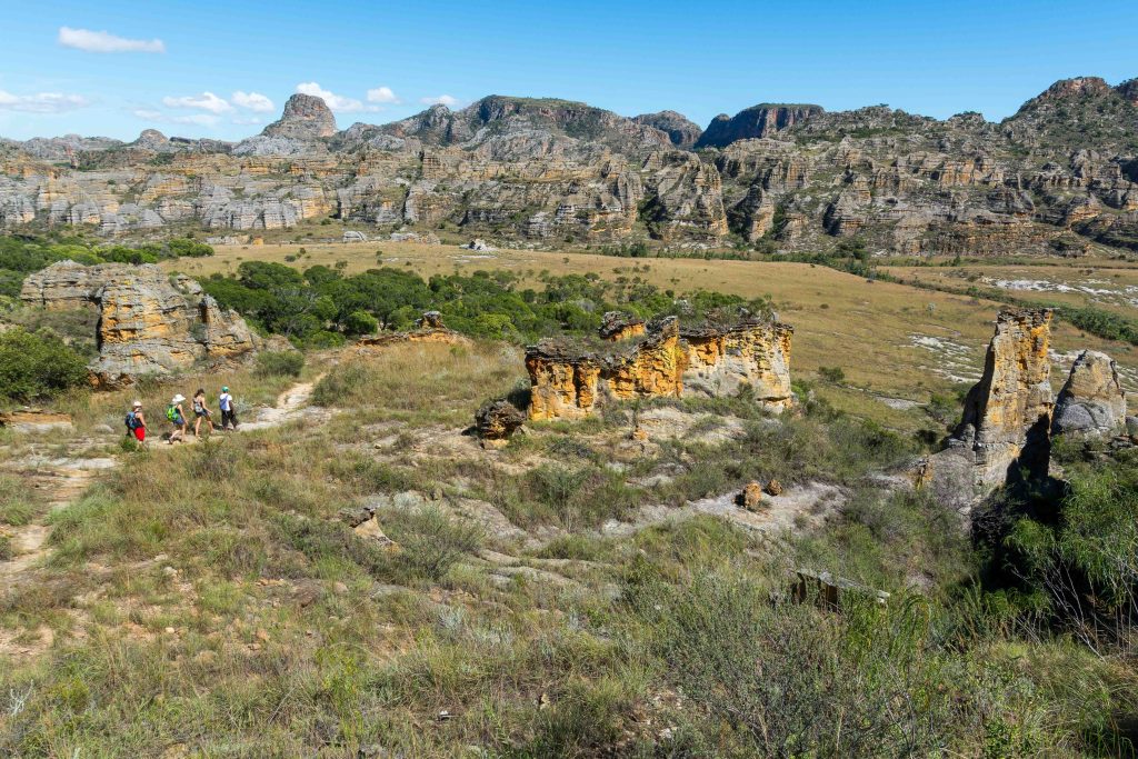
Isalo is Jurassic sandstone cut into canyons, with the Fenêtre de l’Isalo a natural arch positioned so the setting sun drops through the opening.
Cirque Rouge near Mahajanga is a natural amphitheatre of eroded sandstone in reds, ochres and whites, best in late afternoon light.
The Ankarokaroka canyon at Ankarafantsika exposes red and ochre laterite walls, and Andringitra’s granite domes rise above the high grassland with the Tsaranoro Valley’s sheer faces drawing international climbers.

Caves and Underground Systems
Ankarana sits above the longest cave system in Africa, mapped at over 100 km, with underground rivers and blind cave gobies that lost their eyes generations ago. The Grotte des Chauves-Souris holds bat colonies numbering in the hundreds.
Tsingy de Namoroka’s Marosakabe network is mapped at around 113 km, which outstrips Ankarana on paper, beneath a park receiving fewer than five hundred visitors a year.
Anjohibe northeast of Mahajanga has chambers, dripstone formations and underground pools where swimming is possible, with fossil deposits that have yielded subfossil remains of extinct Malagasy megafauna.
Cave access is seasonal at Ankarana, closed December to April because sudden rainfall raises water levels underground with little warning. The Anjohibe track floods in the wet season.
Frequently Asked Questions
What is the highest mountain in Madagascar?
Maromokotro at 2,876 metres in the Tsaratanana massif, which sits inside an integral nature reserve closed to general visitors. Pic Boby at Andringitra, 2,658 metres, is the highest summit ordinary walkers can reach and is the practical objective, on a three-day circuit that occasional hikers manage.
Where are the best waterfalls?
Amber Mountain has the strongest cluster, with the Grande Cascade at around 80 metres, the Petite Cascade on an easier route and the Cascade Sacrée where swimming is possible. Isalo’s Cascade des Nymphes falls into a cold basin in the Namaza gorge. All are reached on park circuits with a guide.
Can I do a river trip?
The Tsiribihina descent is the classic, two or three days by pirogue from Miandrivazo to Belo sur Tsiribihina, camping on sandbanks. It is flat water rather than whitewater. The Manambolo gorge at Tsingy de Bemaraha offers a half day by pirogue, and the Pangalanes canal on the east coast runs from a half day to several.
Where can I swim safely?
The Piscine Naturelle and Namaza pools at Isalo, the Cascade Sacrée at Amber Mountain, Rianasoa at Mantadia and the natural pools at Tsingy de Namoroka are all used routinely. Nile crocodiles occur in rivers and lakes including Lac Ravelobe and the Manambolo, and bilharzia is present in fresh water in some regions. Follow guide instructions.
What is the difference between the tsingy formations?
Tsingy de Bemaraha and Ankarana are ancient limestone, hard karst dissolved over millions of years, walked on and climbed with harnesses at Bemaraha. The Red Tsingy near Diego Suarez is soft laterite carved recently by a river, viewed from paths rather than walked across, and it is actively eroding.
Which lakes are worth visiting?
Lake Alaotra for the bandro, a bamboo lemur living in marsh reeds and nowhere else, on community-run dawn canoe trips. Lake Tritriva near Antsirabe for the crater setting. Tsimanampetsotsa’s soda lake for flamingos. Lac Ravelobe at Ankarafantsika for fish eagles, though swimming is not permitted because of crocodiles.
Can I visit the caves?
Ankarana’s caves are the accessible ones, closed December to April because of flash flooding. Anjohibe near Mahajanga has chambers and underground pools, reached by rough track that floods in the wet season. Namoroka’s system is larger on paper and far harder to reach. All need guides and lamps.
Are these separate attractions or part of the parks?
Almost all sit inside national parks and reserves, which means park entry fees and a compulsory guide. The exceptions are the Avenue of the Baobabs, which is free on a public road, the Pangalanes canal, and Cirque Rouge near Mahajanga. Plan them as part of a park visit rather than as standalone stops.
Planning Your Trip
Madagascar’s natural features are reached on foot with a guide, which means they slot into park visits rather than functioning as separate destinations. The exceptions worth planning around are the Tsiribihina descent, the Pangalanes canal and Pic Boby, all of which take days rather than hours.
Booking Your Madagascar Trip
The safari companies and tour operators listed on this website put trips like this together for a living and know which camps, guides and routes actually deliver. We are an independent guide to Madagascar; we do not book or sell tours ourselves.
When you are ready, arrange your safari, tour or holiday with one of the recognised operators listed here. Tell them your dates and what matters most, and a real person, not a form, will handle the itinerary, park bookings and logistics for you.